“Raster” is a suitably old fashioned term suggesting the scan lines of a cathode ray television screen. “Pixel” is more up to date. Pixel images have a privileged relationship with architecture. Much architecture is about the grid.
Pixel images provide one means of depicting space, i.e. plans and elevations of buildings, zones, regions, city blocks. Floor plans that don’t easily match regularly sized pixels can be stretched, twisted and simplified to conform. Here’s the outline of the Helsinki railway station by Eliel Saarinen adjusted to fit a regular pixel grid.
This crude outline can be stored efficiently as two blocks of information: data about the grid line spacings and the pixel values of the grid cells. Here are the pixel values in binary.
Pixelopolis
At much higher resolution, arrays of pixels are the dominant means of depicting space in the digital age. A cluster of pixels can stand in for a building in plan, a city block, region, a landform, landmark, field, forest or country. Aerial and satellite photography delivers pixel images at various resolutions, scales and values: within and beyond the visible colour spectrum.
Display screens are ubiquitous in cities. From giant billboards to digital watches, display screens present arrays of luminous cellular pixel units.
Algorithms make inferences from pixel values. Through stereopsis, successive image frames from aerial cameras reveal elevation data for cityscapes and landforms. Algorithms derive three dimensional terrain models from elevation data to provide perspective views, or derive slope, exposure to sun, view sheds, heat maps, and contours.
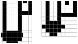
Averaging colour values blurs images. The reverse process sharpens an image. Image editors provide graphic filters: Photoshop, smartphone photo editors, Instagram, etc. Here’s a blurry image on the left undergoing a couple of mathematical transformations to produce the sharper image on the right.
In this case the sharpening is achieved by an algorithm that inspects each pixel in turn and calculates the difference between its value and the average of the 8 pixels that surround it to provide a new value. That process effectively exaggerates the colour value of a pixel in the context of its surrounding pixels — and produces a few artefacts along the way, especially at this resolution and at the edge of the frame.
The blurry image on the left is of the Helsinki station shown above, generated by a simple averaging algorithm. The attempt to sharpen it fragments the original. This demonstration proves that successive manipulation of a pixel image reduces the image’s information content, and it’s hard to get back to the original.
Encryptopolis
As I’m researching the ubiquity of cryptography in architecture, I’m bound to focus on the pixel image. It’s one way of accessing the spatial aspects of encryption. Pixel images can be scaled, compressed and hashed. They can also contain water marks and secret codes — to be explored later. In the meantime, here are some basic pixel image manipulations, constructed on an Excel spreadsheet. Once the algorithm is set up it’s so easy to generate more patterns. So here are some more.
Bibliography
- Barthes, Roland. 1977. The photographic message. Image, Music, Text: 15-31. London: Fontana.
- Foley, James D., Andries Van Dam, Steven K. Feiner, and John F. Hughes. 1997. Computer Graphics: Principles and Practice. Boston, MA: Addison Wesley
- Krawetz, Neal. 2011. Looks like it. The Hacker Factor Blog, 26 May. Available online: http://www.hackerfactor.com/blog/index.php?/archives/432-Looks-Like-It.html (accessed 13 June 2020).
- Lansdown, John. 1987. Computer Graphics. London: Hodder and Stoughton
- Madeira, Antonio. 2019. How does a hashing algorithm work? CryptoCompare, 13 March. Available online: https://www.cryptocompare.com/coins/guides/how-does-a-hashing-algorithm-work/ (accessed 13 June 2020).
- March, Lionel, and Philip Steadman. 1971. The Geometry of Environment: An Introduction to Spatial Organization in Design. London: RIBA Publications
- Mitchell, William, J. 2001. The Reconfigured Eye: Visual Truth in the Post-Photographic Era. Ambridge, MA: MIT Press
- Norman, Richard B. 1990. Electronic Color: The Art of Color Applied to Graphic Computing. Hoboken, NJ: John Wiley
- Ratti, Carlo, and Paul Richens. 2004. Raster analysis of urban form. Environment and Planning B: Planning and Design, (31)297-309.
- Tufte, Edward R. 1990. Envisioning Information. Cheshire, Connecticut: Graphics Press


